Saving Soldiers’ Lives with Mobility Mapping When Off-road Begins
This guest contribution on the Altair Blog is written by Nicholas Gaul, Senior Application Engineer at RAMDO Solutions, a part of the Altair Partner Alliance.
The Department of Defense needs reliable mobility maps for efficient mission planning of troop movement. These maps are important for decision makers to plan routes and operations, select capable vehicles, and assess mission success or failure. The stakes are high, as mission failure often means potential loss of life. RAMDO software, when used in conjunction with terramechanics simulations allows the engineer a way to account for terrain variability, providing improved mobility maps.
The Department of Defense knew their current method of predicting the speed at which they could travel would not be accurate without addressing the variability in the terrain data. One of the biggest reasons traditional mapping is not reliable is because it does not account for the variability of terrain such as slope, elevation, soil properties, etc. Sometimes their data would indicate a route was possible, when in fact, they would get stuck. And on the flip side, it might show a route as impenetrable, when actually, it was a viable option.
RAMDO works in combination with the terramechanics simulation model, allowing engineers to input parameter terrain variabilities. Then it builds a surrogate model of the simulation model, which is much more computationally efficient to run. RAMDO then accurately shows the predicted speeds obtainable at any given probability level. The diagram below shows how RAMDO worked in conjunction with a terramechanics simulation. The variation accounted for was of the terrain input parameters of soil type, soil properties, slope, and elevation. The resulting output distributions was a series of predictive speed maps at any chosen probability level.
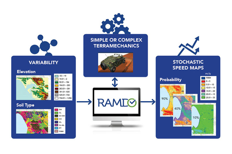 This series of maps, with known probability levels, provides more information to the decision maker, therefore increasing the likelihood of mission success. Without RAMDO, probability levels are unknown and likely provide inaccurate speeds because the simulation did not take into account the variability of the terrain.
With the ability to better predict speed and success of military travel, RAMDO contributes to mission safety with a more cost effective, and reliable solution.
If you are interested in learning more or have questions about Reliability-Based Stochastic Mobility Maps with RAMDO Solutions, contact us at [email protected].
The Department of Defense needs reliable mobility maps for efficient mission planning of troop movement. These maps are important for decision makers to plan routes and operations, select capable vehicles, and assess mission success or failure. The stakes are high, as mission failure often means potential loss of life. RAMDO software, when used in conjunction with terramechanics simulations allows the engineer a way to account for terrain variability, providing improved mobility maps.
The Department of Defense knew their current method of predicting the speed at which they could travel would not be accurate without addressing the variability in the terrain data. One of the biggest reasons traditional mapping is not reliable is because it does not account for the variability of terrain such as slope, elevation, soil properties, etc. Sometimes their data would indicate a route was possible, when in fact, they would get stuck. And on the flip side, it might show a route as impenetrable, when actually, it was a viable option.
RAMDO works in combination with the terramechanics simulation model, allowing engineers to input parameter terrain variabilities. Then it builds a surrogate model of the simulation model, which is much more computationally efficient to run. RAMDO then accurately shows the predicted speeds obtainable at any given probability level. The diagram below shows how RAMDO worked in conjunction with a terramechanics simulation. The variation accounted for was of the terrain input parameters of soil type, soil properties, slope, and elevation. The resulting output distributions was a series of predictive speed maps at any chosen probability level.
This series of maps, with known probability levels, provides more information to the decision maker, therefore increasing the likelihood of mission success. Without RAMDO, probability levels are unknown and likely provide inaccurate speeds because the simulation did not take into account the variability of the terrain.With the ability to better predict speed and success of military travel, RAMDO contributes to mission safety with a more cost effective, and reliable solution.
If you are interested in learning more or have questions about Reliability-Based Stochastic Mobility Maps with RAMDO Solutions, contact us at [email protected].